
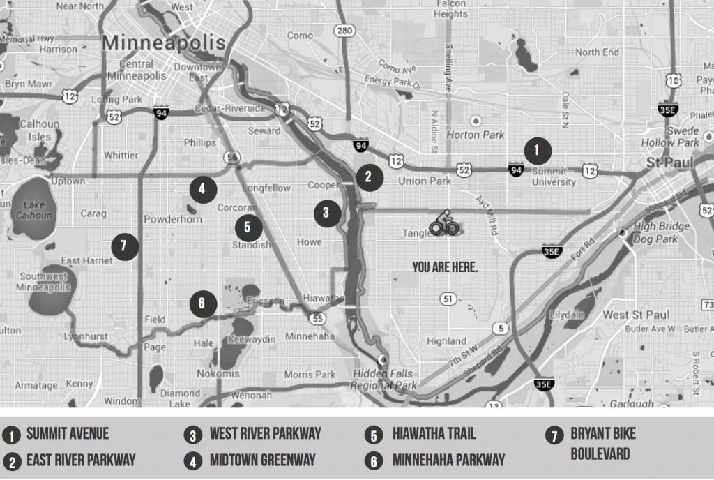
An experience that got me excited about biking in the Twin Cities right away when I came to Mac was a trip to Lake Calhoun. Though the distance seemed a bit formidable, especially to an uninitiated first year, I was amazed at how easy this ride was—if you take a look at the map above, you’ll see that I was able to pedal down Summit to the River Parkways, hop on the Greenway and make a beeline to my destination. My only obstacles on the way were a few stoplights on Summit; other than that, it was basically like being on a bike freeway the whole time.
The notion of a bike freeway may seem strange at first, since the term “freeway” usually conveys cars, concrete and cacophony. But bike freeways truly represent the antithesis of all the noise, pollution and aesthetic blight of our road system. Biking along a bike path like Minnehaha Parkway is an escape from the city air—you’ll feel refreshed by the air that’s isolated from traffic and shared only by the trees that line many of the bike thoroughfares in the Twin Cities. The routes on the map above (excluding Summit) are pedestrian-only, which is less stressful than biking alongside cars, plus you get the added mental health bonus of watching rollerbladers and stopping to pet dogs. These routes also require minimal stop-and-go (you’ll stop for more dogs than stop signs), which means you can get to your destinations remarkably quickly—if you’re a decent biker, it might be faster to take the Greenway through Midtown MPLS than to drive down Lake Street competing with traffic lights and other cars.
Despite the number of people that utilize these main bike thoroughfares, I never view other bikers as adversaries, as I might if I was driving on a crowded road with other cars. Instead of impatience and isolation from others that often accompanies with driving, people on bike thoroughfares share a sense of community and solidarity. When I’m feeling alienated by the concrete jungle of the Twin Cities, I often find taking one of the (bike) roads most traveled by makes all the difference.
Key bike trails near St. Paul
Summit Avenue
• Landmark street just north of Macalester, tree-lined boulevards, beautiful houses and places of worship along the entire road
• The variety, beauty and history of the houses (including the Governor’s Mansion, F. Scott Fitzgerald House, and James J. Hill House) have landed Summit on the U.S. National Register of Historic Places
• Pedal west just a mile and a half to have a picnic or campfire down by the river
• About three miles east to downtown Saint Paul
East River Parkway
• About 16 miles of paved bike and pedestrian-only traffic (Runs from the East Bank of the University of Minnesota, along an extensive park system north of the Mississippi, to the Saint Paul City limits)
• Lined by trees, parks and views of the river
• Access to East Bank of University of Minnesota, Crosby Lake Regional Park, East Bank U of M, Downtown Saint Paul West River Parkway
• About eight miles of paved bike and pedestrian-only traffic (Runs from Downtown MPLS south to Minnehaha Park on the west side of the Mississippi)
• Lined by trees, parks and views of the river
• Access to Downtown Minneapolis, Stone Arch Bridge, the Mill District, West Bank of the University of Minnesota, Lake Street District • Hop on Midtown Greenway north of E 27th St.
• Continue through Minnehaha Park to pedal around Historic Fort Snelling
Midtown Greenway
• 5.5 mile path in South Minneapolis consistently named among the best urban bike trails in the U.S. Almost completely traffic-free, you’ll probably only stop once or twice
• Connects with a great route system around the Minneapolis Chain of Lakes and extends to the West River parkway
• Runs parallel to Lake Street, which offers a multitude of shops, restaurants and other businesses
• Fun pedestrian-only bridge runs over Hiawatha Avenue
• Freewheel Midtown Bike Center right on the Greenway (you can refuel at the small café here). You can also perform minor adjustments on your bike at several tool stations along the way
Hiawatha Trail
• Take this trail from the Midtown Greenway (east of Hiawatha Ave. before the Martin Olav Sabo Pedestrian Bridge) directly to Downtown Minneapolis! You’ll end up just north of the Metrodome with easy access to bus transit options and nice bike lanes. You can also pedal south to Minnehaha Parkway
Minnehaha Parkway
• Beautiful bike parkway that runs through south Minneapolis from the Chain of Lakes to Minnehaha Falls Park (and connecting up to West River Parkway)
• Instead of following a major road, it follows Minnehaha Creek, which is lined by trees and parks instead of cars and buildings. Has my vote for most beautiful path in the Twin Cities!
Bryant Bike Boulevard
• If you hop off at Bryant Ave after traveling the Greenway, you’ll end up on Bryant Bike Boulevard—this road, though accessible to local traffic, is specifically designed for bikes and pedestrians. You can use the whole lane without having to worry about cars, and it is a great route to pedal into downtown Minneapolis!











Lauren Berry • Sep 11, 2019 at 4:35 pm
Hello there, just changed into alert to your weblog thru Google, and found that it is truly informative. I am going to be careful for brussels. I’ll appreciate when you proceed this in future. Lots of people can be benefited from your writing. Cheers!
Yvonne Hamilton • Sep 5, 2019 at 1:36 pm
As a Newbie, I am always searching online for articles that can help me. Thank you